The Best Backpacking in Sedona
Looking for the best backpacking in Sedona? We've got you covered with the top trails, trips, hiking, backpacking, camping and more around Sedona. The detailed guides, photos, and reviews are all submitted by the Outbound community.
Top backpacking spots in and near Sedona
-
Sedona, Arizona
Oak Creek via Huckaby Trail
3.07 mi / 548 ft gainOak Creek via Huckaby Trail is an out-and-back trail where you may see wildflowers located near Sedona, Arizona.Read more -
Sedona, Arizona
Girdner Trail
10.18 mi / 1076 ft gainGirdner Trail is an out-and-back trail that takes you by a river located near Sedona, Arizona.Read more -
Sedona, Arizona
Mescal, Aerie, Cockscomb and Dawa Loop
13.29 mi / 1227 ft gainMescal, Aerie, Cockscomb and Dawa Loop is a loop trail that takes you by a river located near Sedona, Arizona.Read more -
Sedona, Arizona
Hot Loop, Schnebley Hill, Munds Mountain and Jack's Can Trail
22.75 mi / 3684 ft gainHot Loop, Schnebley Hill, Munds Mountain and Jack's Can Trail is a loop trail where you may see local wildlife located near Sedona, Arizona.Read more -
Sedona, Arizona
West Fork Trail
5.06.49 mi / 1102 ft gainThis is one of the most beautiful hikes in Sedona, Arizona. It is a fairly easy hike, although it is 6 miles roundtrip. A lot of families come here, and children love to play in the water. There are various stream crossings, but for most of them, you should be able to keep dry. The canyon walls ...Read more -
Williams, Arizona
Hike the Kelsey Spring/Hog Hill/Dorsey Spring Loop
13.4 mi / 2200 ft gainThis hike starts at the Kelsey Spring Trailhead. Park at the end of Forest Service Road 538G. There is parking for about 6-7 cars. Just past the signage for the trail, which is also called Kelsey Winter Trail, there is a trail registration box. Be sure to sign in. The trail descends steeply for t...Read more -
Sedona, Arizona
Parsons Trail
7.27 mi / 587 ft gainParsons Trail is an out-and-back trail that takes you by a river located near Clarkdale, Arizona.Read more -
Gold Canyon, Arizona
Sycamore Basin Trail
55.55 mi / 7293 ft gainSycamore Basin Trail is an out-and-back trail that is strenuous located near Clarkdale, Arizona.Read more -
Coconino County, Arizona
Hanging Garden OHV Route
12.14 mi / 1555 ft gainHanging Garden OHV Route is an out-and-back trail in the West Creek Wilderness located near Strawberry, Arizona.Read more -
Flagstaff, Arizona
Weatherford Trail to Humphreys Peak
22.94 mi / 5112 ft gainWeatherford Trail to Humphreys Peak is an out-and-back trail where you may see wildflowers located near Flagstaff, Arizona.Read more -
Yavapai County, Arizona
Verde Hot Springs
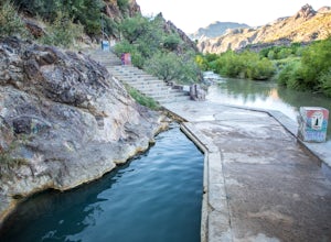
3.32.46 mi / 118 ft gainThe pools at the Verde Hot springs are the remnants from an old resort built in the 1920's. The resort was a once thriving tourist attraction and also rumored to be one of Al Capone's hideouts. In the 1960's a fire destroyed the resort only leaving behind the foundation and the thermal pools al...Read more -
Mayer, Arizona
Verde Rim Loop Trail
14.32 mi / 2631 ft gainVerde Rim Loop Trail is a loop trail where you may see beautiful wildflowers located near Camp Verde, Arizona.Read more -
Pine, Arizona
Oak Spring Trail
7.41 mi / 1168 ft gainOak Spring Trail is an out-and-back trail where you may see wildflowers located near Pine, Arizona.Read more -
Payson, Arizona
Cabin Loop Trail
18.82 mi / 2028 ft gainPeople think Arizona is all just desert, but this hike will show you otherwise. Up on the Mogollon Rim, this trail takes you past old cabins, through lush forest, and near many creeks. Day 1: (10 miles) Drive on Rim Road to the General Springs Trail Head. The cabin marks the start of the tr...Read more -
Payson, Arizona
Mogollon Rim via Washington Park
4.04.32 mi / 1138 ft gainThis trail begins at the Washington Park Trailhead which meets up with passage #27 of the AZT. You begin traveling northbound as you ascend the great Mogollon Rim. The trail takes you through a gorgeous forest and rewards you with an awesome cliff side view at the summit. 2.25 miles into the tra...Read more -
Payson, Arizona
Hike the Colonel Devin Trail
4 mi / 1116 ft gainThe hike will begin at Washington Park in Payson, Arizona. To reach Washington Park, take AZ87 to Forest Road 199 (Houston Mesa Road) and turn east. Continue for 10 miles until you reach Forest Road 64 and turn west. Traveling less than a mile you will turn north on Forest Road 32 and in 3 miles ...Read more


