
Kings Peak
Evanston, Utah
Details
Distance
28.56 miles
Elevation Gain
5213 ft
Route Type
Out-and-Back
Description
Added by Jacob Moon
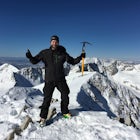
Summit Kings Peak, Utah's tallest mountain at 13,527 feet (4,123 meters). Inspiring views of all of Utah's 13,000+ foot peaks.
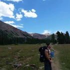
From the Henry Fork Trailhead (approx. 9400 feet elev.) the trail gains very little elevation during the first 5.5 miles with several lakes to camp by along the way. The first lake reached is Alligator Lake. At just under 3 miles from the trailhead, this beautiful lake is an excellent choice for those who are looking for a nice, easy introduction to the altitude and rigors of backpacking. After passing Alligator Lake the trail continues on the Henry's Fork Trail for another 3 miles. At this point, you'll reach a trail junction known as ElkHorn Crossing. Here you are presented with two choices:
1) You can take the trail heading due south. This trail is the most direct route. After 2 miles, it will pass by the most popular lake in the area, Dollar Lake, which has a numbers of excellent established campsites near by.
2) You can take the West Loop Trail which will add ~4.5 miles to you trip. This is a excellent option either going to or coming back from Kings Peak because of its half a dozen picturesque lakes, excellent campsites and fewer crowds. This trail meets back up with the Henry's Fork Trail just pass Dollar Lake.
It is highly recommended to set up base camp near one of the many lakes in the Henry's Fork Basin. At this point, the trail begins to gain elevation rapidly up switchbacks to Gunsight Pass (11,900 ft elev.). From the top of the pass, the trail descends 500 vertical feet into the next drainage and loops around the steep, rocky slopes of Gunsight Peak to once again ascend the gentler, though still rocky slope of Kings Peak. This last and final section of the trail gains approx. 2000 feet over 4.6 miles to The Crown of Utah 13,527 ft.
Download the Outbound mobile app
Find adventures and camping on the go, share photos, use GPX tracks, and download maps for offline use.
Get the appFeatures
Reviews

Great hike. We camped at Alligator Lake and then started our hike the next morning. Super gradual incline until the very steep end. We got rain/sleet at the top, but it was great overall!
5.0
In my opinion, this is the way to summit King's Peak. Backpacking in gives you the time to enjoy the beautiful basin, explore other lakes and spend time on the peak to soak it all in. Incredible adventure!
5.0
Good scenery mix the whole hike. We climbed up the rock slide to the right and then down that way also- on all fours both ways- great challenge, staying overnight was relaxing and peaceful as well. Highly recommend this beautiful hike.
4.0

I did this hike in late July last year. The hike itself is super moderate and is honestly mostly flat the entire way -- until the last little stretch to the summit. The views from the top were incredible, though. I went on a really clear day, and you could see for miles in any direction. I loved looking around and see all the different valleys and small lakes in the Uintas. It was lovely. I did it two days. We hiked about 8 miles until we found a good camping spot close to a lake. Then, we woke up early, hiked to the peak, came back to camp for a quick lunch / nap and then hiked back to the trailhead. We got to the trailhead before sunset, and I was back in Provo by 11 pm. It was a great hike.
5.0
This can also be done as a *long* day hike (took us 15 hours). We left Salt Lake City at 1am and were at the trailhead and walking by 4am. The trail is clearly marked and easy to follow up to Gunsight Pass. After that, it branches off in a few different directions. You can head straight down to Upper Painter Basin and lose 500 feet of elevation (like the author did here), or you can turn right up a “shortcut” over Anderson Pass (also the base of Gunsight Peak) that’s marked by cairns and a narrow climber’s trail. Once on top of the pass, you’ll be able to see the main path ahead of you and the notch where people start off on the North Ridge Route. On both the shortcut and on King’s Peak itself, there are cairns virtually everywhere, which makes it difficult to decide which markers to follow. Big note: Lots of scrambling involved towards the summit, not dog-friendly. Rocks will get very slippery in precipitation. Weather forecast for our day was hot and sunny, but we ended up getting caught in a 3-hr hail + lightning storm. Bring storm gear, plenty of food, and have fun!
5.0

Great review of a fantastic hike. This is one of the best treks in the Uintahs.
5.0
I just did this hike last weekend with two friends. It was a LOT of fun, and tough. We hiked in Saturday to our site, which was about 10 miles in from the trailhead, near a waterfall. Hung out around the site for a bit, explored a bit, then finally had dinner and went to bed by 8PM. Got up at 2AM, were hiking by 3AM, were on the summit at 7:17AM, and back to camp by 10AM. We hung out a bit there, ate lunch, and then left, and were back to the trailhead by 5PM. To add more detail to the route description, everything is easy to find and well marked up to the top of Gunsight Pass. We took the short way towards Dollar Lake when we got to the Elkhorn Crossing intersection. Next time I will set aside more time for the hike and take the long way at Elkhorn. After Gunsight Pass, it gets far less tracked out. The trail isn't as obvious, which is a lot tougher at 4AM with no light. Luckily, we did have a full moon (night before the super blood moon we just had), which gave us far more light than we would have with a new moon. Carins are spaced out and pretty large for a while, but we ended up getting off trail when we had started working our way up to Anderson Pass. This left us scrambling over the rocks at the base, instead of being on the smoother trail up to Anderson. If it's dark, go slowly and scan everything for the carins. On the way down from the peak, we hugged the ridgeline pass Anderson, and dropped back into the area we were camping via the wide, steep chute about 1/4 - 1/2 mile from where the Anderson Pass trail crests the pass. This route cuts ~4 miles off your trip, but it's *really* steep, and very loose. Space out if you do this route with multiple rocks, because as you walk, you're knocking rocks down the slope, and they sometimes roll far and bounce high. Next time I do King's Peak from this trailhead, I am not sure I'd do this route down again. For campsites in the area, be aware that there are a lot of swampy areas. They're generally pretty easy to spot, as they are covered in short brush. Navigating around and through them can be an adventure, and it was nice having the legs zipped on for it. There are LOTS of places to camp, and we had water sources. We were near a waterfall at just under 11,000' elevation. Lakes all over, and streams were pretty easy to find. If you have ankle issues, or have had ankle injuries in the past, boots may be nicer than hiking shoes. I fractured my ankle just over a year prior to doing this hike, and my boots helped me reduce motion when I rolled it a couple times on this hike.
5.0
Great adventure! The whole thing in general was easier than expected, but it was difficult nonetheless! Make sure you're totally prepared with all the necessary equipment. I developed several blisters, but it wasn't anything unbearable.
5.0
Make sure you have the right gear for the elements you will be hiking in!
Leave No Trace
Always practice Leave No Trace ethics on your adventures and follow local regulations. Please explore responsibly!
Nearby

Red Castle and Red Castle Lakes

Backpack to Red Caslte Lake and Mt. Wilson

Hike to Tokewanna Peak in the High Uintas

Backpack to Dead Horse Lake

Backpack Mount Beulah via East Fork of the Bear River Trailhead

Kermsuh Lake Trail
Community
Mobile Apps

© 2023 The Outbound Collective - Terms of Use - Privacy Policy