
Guadalupe Peak Trail
Culberson County, Texas
Details
Distance
8.15 miles
Elevation Gain
2867 ft
Route Type
Out-and-Back
Description
Added by Tim Holland
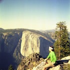
Guadalupe Peak is the highest point in Texas. It sits on the New Mexican boarder and rises out of the desert. Its a fun day hike with some pretty good bragging rights to go with it.
It's na 8.5 mile round trip that has an elevation gain of over 3000 ft. The trail is a lot of switch backs which help you gain that 3000 ft very quickly. The first 1.5 miles is the roughest; once you get past that it's not easy, but it's not as steep. After the first mile and half, you will turn and start to go up the north facing slope, where you'll find a forest of Pinion Pine, South-Western White Pine, and Douglas Fir. This might be the only shade you find on the hike, it is Texas after all so expect it to be hot. As you continue to climb you will get an awesome view of El Capitan to the South. The view at the top is worth it. These mountains spring up out of the desert and are the highest points for miles.
Download the Outbound mobile app
Find adventures and camping on the go, share photos, use GPX tracks, and download maps for offline use.
Get the appFeatures
Reviews

I did not summit, but what I did get to do was fabulous. Went in April. The views are awesome. This is a hard hard trail. Depending on your skill level. Bring lots of water. At least 3 sets of switchbacks. There is a primitive camp at least a mile from the summit. Nice trail to night hike too. The sunset was beautiful.
4.0

Although one of the more popular hikes in the park, Guadalupe Peak demands more out of the hiker. We started well before sunrise and were treated to a beautiful view about mid-way up the mountain. Make sure to bring lots of water, especially if you are hiking during the middle of the day. I drank over 2 liters and most of the hike was in the dark. The views are great from the top. Nothing very technical required to get to the summit; just endurance! Happy hiking!
5.0
This is a fun hike that offers some really great views and cool geology (if you're into that kind of thing). Bring plenty of water, especially during the hot months!
5.0

Tough hike but well worth it! 4.2 miles one way, over 3,000 ft climb in elevation. There's a false peak, and the beginning is the hardest part of the trail. There's camping at the base of the trail, and another campsite near the top of the trail for those who enjoy backpacking.
4.0
This is a beautiful hike that I highly recommend, but be aware of high winds, I nearly lost my tent because I didn't stake it down when it was calm. Then in the middle of the night I had a tent pole break on me due to the winds. It caught me by surprise.
4.0

Be sure to check if the park is open. There is currently a wildfire that has closed much of the park.
5.0

This is absolutely worth it and a little know gem in Texas - much less busy than Big Bend. I'd suggest doing a hike to the top of the peak to catch sunrise if you can! There is also some primitive campsites on the way up to the top of the peak. Make sure you bring plenty of water.
5.0

I went out here for a long weekend and started my trip off with this hike. Its a rough hike up, you gain over 3000 ft in 4 miles, but the view is outstanding.
Leave No Trace
Always practice Leave No Trace ethics on your adventures and follow local regulations. Please explore responsibly!
Nearby

El Capitan in Guadalupe Mountain NP

Hunter Peak Loop

Devil's Hall Trail

Pinery Trail

Smith Springs Loop

McKittrick Canyon Trail to McKittrick Ridge Campground
Community
Mobile Apps

© 2023 The Outbound Collective - Terms of Use - Privacy Policy