
Hike the Temescal Canyon Loop
Los Angeles, California
Details
Distance
3.4 miles
Elevation Gain
1100 ft
Route Type
Loop
Description
Added by Lucas Pols
Great leg burning cardio with incredible views and scenery of the Pacific Palisades, Santa Monica, and the ocean!
There are a couple of different ways that you can hike in Temescal Canyon.
Options for Hiking Temescal Canyon:- The basic loop – 2.6 miles
- The loop beginning from Temescal Canyon Trail at Sunset Boulevard – 3.4 miles
- The loop with the Bienveneda Trail extension – 3.25 miles
- The loop beginning from Temescal Canyon Trail at Sunset Boulevard with the Bienveneda Trail extension – 4.05 miles
- The loop with the Skull Rock Extension – 3.8 miles
- The loop beginning from Temescal Canyon Trail at Sunset Boulevard with the Skull Rock extension – 4.6 miles
- The loop beginning from Temescal Canyon Trail at Sunset Boulevard with the Bienveneda Trail extension and the Skull Rock extension – 5.25 miles
The hike is not an easy one but can be made more difficult depending on which part of the loop you start on.
If you take a left at the Temescal Canyon Trailhead, which starts on Sunset Boulevard, you will gain the 1,100 feet of elevation much more quickly and will be in for an intense workout.
If you go right the incline will be much more gradual for the majority of the climb with a steep downhill once you have reached the top.
Tips:- There is parking located inside of the park but it can fill up quickly so get there early! It costs $7 to park and you will need cash or a check to deposit it into the "Iron Ranger"
- If you cannot find parking in the lots try looking down Temescal Canyon Road!
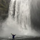
- The waterfall that used to exists here no longer does because of the drought.
- If you do not want to hike there are a lot of places to have picnics and enjoy the scenery!
The hike is a favorite of most of the locals in the Palisades and worth a try!
Download the Outbound mobile app
Find adventures and camping on the go, share photos, use GPX tracks, and download maps for offline use.
Get the appFeatures
Reviews
Lots of parking at the beginning of the trail, but can be really busy during the weekends. If you go during the summer times, it can get really hot, so bring lots of water, wear a hat, and wear sunscreen. If it’s not overcast, you can see some of the most amazing views from the top.
4.0


I enjoyed this hike. It had an easy to follow trail and nice views of LA and the greater area. Went on a weekend and ran into a lot of people, which is to be expected, but it wasn't horrible in terms of LA crowds.
4.0
This hike is a good standard in the Santa Monica Mountains. If you do it clockwise, the beginning is far more exposed then the 2nd half. When the sun is out and it's warm be prepared to be blasted in the first half, the shade is infrequent. It does get better towards the end, trees start to surround the trail and shade becomes constant. You'll see a lot of people doing this trail in running shoes, not hiking boots. The trail is patted down and finding good grip is not an issue, nor is there any scrambling. I'd prefer a hike with lush forest but this hike is predominately bushes and small trees.
3.0

Nice casual hike for beginners but not especially scenic or challenging . Considering places like Yosemite are 5 stars this has to be rated lower.
2.0
It is beautiful, amazing views and an amazing walk! Love it
5.0
I love this hike. It's long enough and steep enough that I always feel like I got a real hike in (in contrast to some of the westside routes that are more glorified walks than hikes), the views at the top are great (on a clear day), and the terrain varies widely from dry chaparral to lush forest. This hike is so close to the westside, has free and easy parking on Temescal Canyon Road, and when you're done, it's a quick 10 minute jaunt to the Brentwood Country Mart for ice cream.
5.0
Leave No Trace
Always practice Leave No Trace ethics on your adventures and follow local regulations. Please explore responsibly!
Nearby

Inspiration Point Loop Trail

Backbone Trail via Will Rogers State Park

Hike to the Parker Mesa Overlook

Hike to Murphy's Ranch

Run the Santa Monica Wooden Stairs

Los Liones Trail
Community
Mobile Apps

© 2023 The Outbound Collective - Terms of Use - Privacy Policy