
Hike to the Ramsey Cascades
Gatlinburg, Tennessee
Details
Distance
7.83 miles
Elevation Gain
2190 ft
Route Type
Out-and-Back
Description
Added by Joshua Contois
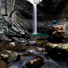
Hike to Ramsey Cascades, one of the tallest waterfalls in Great Smoky Mountains National Park (100 ft) on a challenging trail through an old-growth forest.
This multi-tiered waterfall is known as the tallest in the park – a worthwhile reward for the steep and sometimes tricky terrain you'll face on the way up.
The popular route to the falls also passes through an impressive old-growth forest, which apparently boasts some of the tallest trees in the park. You will also see smaller waterfalls and pools along the way.
Keep in mind that about 2 miles into the hike you will need to pass over a fairly long, narrow footbridge. Also please remember that climbing is prohibited on the rocks around the falls.
Download the Outbound mobile app
Find adventures and camping on the go, share photos, use GPX tracks, and download maps for offline use.
Get the appFeatures
Reviews

This trail was so beautiful I would recommend to anyone🤩 the waterfalls and creeks and giant trees. Just wow. If you love nature you will love this trail.
4.0

This hike is worth the effort and is a right of passage of Great Smoky Mountains National Park. I have visited it in all seasons.
5.0

This hike truly shows the beauty of the Great Smoky Mountains and what they have to offer.
5.0

This hike was amazing. It was difficult for my family but considering it was only our second hike we did very well. We made an entire day of it and did not get into a hurry. Packed a lunch to enjoy at the top. We refilled our water bottles along the way as so not carry so much weight. Our family was kids ages 8, 10, 11, 12. GrandParents ages 67/68, and I’m 35! We went in around 10:45 and finished up a little after 6pm. According to my Garmin Forerunner we hiked a total of 9.73 miles. So it’s a little longer than 4 miles to the top. Enjoyed it!
5.0

A challenging but beautiful hike to the falls. You follow a gushing stream along the way and a bit of a scramble near the falls. Every step is worth it!
5.0
Getting to the trailhead can be tricky for anyone with a sports car, as the road that leads through the park is gravel and bumpy at points. Be prepared for single car width portions of the road. The hike begins with a gradual incline which may fool some into believing that this is an easy hike, psyche!The last half mile is killer, be prepared for a lot of stone steps. This is definitely a hike where you want to wear high ankles boots. I recommend bringing aqua socks, because at the top you can walk right up to the falls, since it plateaus directly underneath. The hike totaled 8.2 miles on my Fitbit Surge. The difficulty of the hike is only surpassed by the reward of the falls.
5.0

This hike was absolutely amazing I would do it again tomorrow if I could. If your looking for a challenge with a great reward this is the hike for you. There was a sign that said it was closed but we drove 1hr30min to get there so we just went for it. One of the foot bridges was out so we hopped rocks across that part. The last 2 miles are the most difficult. We practically ran the whole way down. We got there at 10 and ended at 230. We spent about 45 min at the top and stopped 3 or 4 times along the way. Bring lunch and beer for the top!
5.0

This trail is EXHAUSTING! It feels much longer than 8 miles. It is an out and back trail with absolutely beautiful views and the sound of the creek almost the entire way to the falls. HOWEVER, this trail is up hill the entire way to the falls. No flat land and many, MANY rocks. You will need good hiking boots and I'd recommend a walking stick. We started the trail at 4 in the afternoon and ended up hiking in the dark, not returning to our vehicle until 9. Once you get to the top, it is breathtaking. These are the largest falls in the smokies at 20 feet high. I would not recommend swimming since its very slick and rock and basically if you slip and fall you will die. This was the hardest trail I have done this far but it was the best reward at the end. Coming back isn't as bad as going up since its all down hill. Just watch your step.
5.0

This was a challenging but exciting hike. Might be good to mention the thin bridges for anyone nervous about heights. Excellent view at the top. I was so tired, I was ready to give up, but was SO GLAD I didn't. Would hike again.
5.0
Not the easiest trail but it is very scenic and the waterfall is definitely worth it
5.0
Leave No Trace
Always practice Leave No Trace ethics on your adventures and follow local regulations. Please explore responsibly!
Nearby

Fern Branch Falls

Grotto Falls Trail

Maddron Bald - Albright Grove Loop

Photograph the Smokies from Morton Overlook

Camp out at Mt. LeConte Lodge via Alum Cave

Hike to Mt. LeConte via Alum Cave Bluff
Community
Mobile Apps

© 2023 The Outbound Collective - Terms of Use - Privacy Policy