
Table Mountain, Cape Town
Cape Town, South Africa
Details
Distance
1.9 miles
Elevation Gain
2300 ft
Route Type
Out-and-Back
Description
Added by John Chau
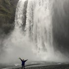
Trek up to the top of one of the world's most iconic landmarks, Table Mountain, designated in 2011 as one of the world's new Seven Wonders. The grueling hike up to the summit is rewarded by splendid views of the Cape, and with tons of natural features from rare fynbos to wildlife, Table Mountain is a must-visit when in Cape Town.
After parking at the lot near the Platteklip Gorge trailhead, start hiking south up the path. It soon will become extremely steep with large slabs of rock acting as some sort of giant stairs that us peons must crawl over until we eventually reach the summit. If you have long legs and are taller than average, you might find this hike to be a breeze, but it can be quite a strenuous hike for those of us who are small.
There are other hikes that aren't as steep to the summit, but Platteklip Gorge is the quickest. With less than 2 miles of hiking and an approximately 2,300 feet elevation gain, it's steep. Simply stay on the main trail that heads south up the mountain and ignore the east-west trail that you'll come to right before the switchbacks that head up into the steep gorge that divides Table Mountain in two. Continue on up the zigzags into the gorge and take a moment to pause, catch your breath, and look back at the view behind you.
When you reach the top of the gorge, you'll come to a 4-way junction.
Going right (NW) will take you to the plateau part of table where the cable car station, bathrooms, gift shop, and lookouts are.
Going left (SE) will take you to a Y-junction, with the left trail leading on a loop around the eastern part of the plateau (Maclear's Beacon) and over towards the Skeleton Gorge/Smuts Track trail (a longer trail on the south-eastern side of Table Mountain that starts/end at the Kirstenbosch Botanical Gardens) and the right heads down to lakes Hely-Hutchinson and Noodhead, two large dams (that are rumoured to contain trout) and meanders around to the backside of Table Mountain via the Corridor Ravine.
Heading straight through the 4-way junction (SW) will take you towards the back of Table Mountain and can be linked up with the Corridor Ravine route.
**NOTES: If you decide to take the cable car down, you'll need to either hire a taxi or walk the 4 km back to the Platteklip Gorge Trailhead parking lot.
Stay on the paths and don't get too close to the edges of the cliffs - numerous tourists have fallen and died from being careless on Table Mountain.
Hike with (a) friend/s - there have sometimes been muggings and attacks on hikers, so use common sense and don't display your wealth openly.
The weather can change rapidly on the mountain, so even if it's sunny out when you start it might become low visibility fog in an hour.
Maps can be bought for a donation at the small ranger station at the trailhead.
Trad climbing is allowed on Table Mountain, with most of the popular routes below the cable car station.
Caving on the backside of Table Mountain in its sandstone caves can be exhilarating as well.
Download the Outbound mobile app
Find adventures and camping on the go, share photos, use GPX tracks, and download maps for offline use.
Get the appFeatures
Reviews
Since I was traveling solo, I took the cable car to the top and back down again. Amazing and beautiful views of the coastline and the city. Make sure to bring layers because it can get pretty breezy at the top.
5.0
This trek was one of my favorite I have ever done! Such an amazing and beautiful feature of South Africa. The hike up to the summit led to splendid views of the Cape and there was wildlife along the way. I'm so glad I visited Table Mountain while I was in Cape Town.
5.0

This is the same trail I did when I hiked up Table Mountain! I think you outlined it well, because it can be a bit confusing. I would definitely recommend getting a map and planning out your hike before hand. The views from the top are stunning, it was a cloudy day when I hiked, so we were going through fog a lot of the way. But when we got to the top our heads were peaking out over the clouds. Really stunning!! I advise bringing lots of water and a rain jacket also because the weather changes instantly in Cape Town.
5.0
Leave No Trace
Always practice Leave No Trace ethics on your adventures and follow local regulations. Please explore responsibly!
Nearby

Hike Table Mountain via Platteklip Gorge Trail

Hike up Devil's Peak

Table Mountain's India Venster Route

Hike Tranquility Cracks via the Pipe Tracks

Hike to Wally's Cave on Lion's Head

Shark Diving in Gaansbai
Community
Mobile Apps

© 2023 The Outbound Collective - Terms of Use - Privacy Policy