The Best Hiking in Ramona
Looking for the best hiking in Ramona? We've got you covered with the top trails, trips, hiking, backpacking, camping and more around Ramona. The detailed guides, photos, and reviews are all submitted by the Outbound community.
Top hiking spots in and near Ramona
-
Ramona, California
Ramona Community Park
0.8 mi / 42 ft gainRamona Community Park Is a loop trail that is moderately difficult located near is a loop trail that is good for all skill levels located near Ramona, CaliforniaRead more -
Ramona, California
Barnett Ranch Preserve
3.84 mi / 269 ft gainBarnett Ranch Preserve is a loop trail where you may see wildflowers located near Ramona, California.Read more -
Ramona, California
Simon Open Space Preserve Trail
3.86 mi / 682 ft gainSimon Open Space Preserve Trail is an out-and-back trail where you may see beautiful wildflowers located near Ramona, California.Read more -
Ramona, California
Orosco Truck Trail
15.35 mi / 2234 ft gainOrosco Truck Trail is an out-and-back trail located near Ramona, California.Read more -
Ramona, California
Gunstage Trail
3.02 mi / 161 ft gainGunstage Trail is an out-and-back trail that is good for all skill levels located near Ramona, California.Read more -
Escondido, California
Clevenger Canyon South West Trail
4.39 mi / 1099 ft gainClevenger Canyon South West Trail is an out-and-back trail where you may see beautiful wildflowers located near Ramona, California.Read more -
Ramona, California
Pamo Road Trail
5.03 mi / 194 ft gainPamo Road Trail is an out-and-back trail where you may see local wildlife located near Ramona, California.Read more -
Ramona, California
Boden Canyon Loop
14.27 mi / 1762 ft gainBoden Canyon Loop is an out-and-back trail that takes you by a river located near Ramona, California.Read more -
Ramona, California
Ramona Grasslands Preserve Trail
3.1 mi / 249 ft gainRamona Grasslands Preserve Trail is a loop trail where you may see wildflowers located near Ramona, CaliforniaRead more -
Ramona, California
Dos Picos Park
1.45 mi / 197 ft gainDos Picos Park is a loop trail that takes you by a lake located near Ramona, California.Read more -
Ramona, California
Woodson Mountain via Fry-Koegel Trail
7.48 mi / 1490 ft gainWoodson Mountain via Fry-Koegel Trail is an out-and-back trail that is moderately difficult located near Poway, California.Read more -
Ramona, California
Woodson Mountain and Potato Chip Rock via Hwy 67
4.1 mi / 1296 ft gainWoodson Mountain and Potato Chip Rock via Hwy 67 is an out-and-back trail where you may see wildflowers located near Ramona, California.Read more -
Ramona, California
Hiking Mount Woodson's East Approach
3.04 miMount Woodson is a well know hiking trail in San Diego County. It is know for its breath taking views and the famous potato chip rock. The Trail on the east side of the Mountain is fairly steep but is about half the distance of the trail on the west side of the mountain. To get to the trail on t...Read more -
Ramona, California
Black Mountain OHV Trail
14.35 mi / 3041 ft gainBlack Mountain OHV Trail is an out-and-back trail where you may see wildflowers located near Ramona, California.Read more -
Ramona, California
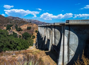
Explore the Sutherland Dam
2.01 miOnce your on Sutherland Dam Rd, follow it until your right next to the dam. Park on the side of the road where you see a small turn-out. Walk down to the side of the dam and drop down onto the concrete flooring of the dam. Walk on-top where allowed, and check out the views of the lake and the mo...Read more -
Ramona, California
West Side Road Trail
4.52 mi / 761 ft gainWest Side Road Trail is an out-and-back trail that takes you by a waterfall located near Ramona, California.Read more


