
Appalachian Trail - First 5%
My experience hiking a section of the Appalachian Trail - 10 days, one "dank" mountain and infinitely many good times.
Hiking the Appalachian Trail (AT) has been a dream of mine for the
better part of the last 5 years since I first started backpacking. Like
most people with this dream though, I am in a career that doesn’t
exactly lend itself to taking five to six months off to plod along in
the woods on the way to Maine. Instead of taking on this massive ~2200
mile trek all at once, I’ve been happy breaking it into smaller sections
with a few trips a year to places like Grayson Highlands, Harpers
Ferry, and now, the southern terminus at Springer Mountain to Nantahalla
Outdoor Center (NOC), NC! In this entry, I will cover the first half of
the trip with accounts about each stopping point and what happened in
between. Hope you enjoy!

On October 8th, 2020, my journey on the lower 5% of the AT began with a short flight from Baltimore to Atlanta, a shuttle ride to Springer Mountain,
and, anticlimactically, relaxing atop the mountain listening to an
audio book. My hiking buddy, Mark “Agent Orange” Evans, was joining me
for this adventure and his flight was arriving a couple hours after
mine. Since we were doing this hike in the days of COVID-19, neither of
us wanted to risk further exposure opportunities at the airport so we
decided to meet at the trailhead. That first day, sitting near the trail
marker, I had some time to reflect on the massive section hike we were
about to begin… We were scheduling ourselves to average 14 miles of
hiking a day for the next 10 days over which time we would cover 136.7
miles, ascend an estimated 36,520 feet (1.25 times the altitude of
Everest!), and descend 38,580 feet. Furthermore, we’d be carrying food
for five days at a time (1.5 – 2 lbs. per day), water, and our
backpacking gear which, all together, added up to around 30 lbs. fully
loaded. It was a bit intimidating! It was at this point, the very
beginning of our journey, that I decided it would be healthier mentally
for me to look at the trip one day at a time as the whole big picture
was too crazy to comprehend. That first night we hiked a mile total to
Springer Mountain Shelter in preparation for a big day the next day to
our planned first stop, Devil’s Kitchen campsite.

As would become typical of our plans, they ended up changing the first
day we hit the trail to include MORE mileage! Knowing that Tropical
Storm Delta was in the region and that we would prefer to not carry wet
tents and hammocks all of day two, Mark and I adjusted our schedule and
mileage to allow us to make it to Gooch Mountain Shelter,
an AT shelter that features a sheet metal roof, bear boxes and cables,
and a fresh water spring! On our way there we hiked over Hawk Mountain,
which left no impression on me, and passed Long Creek Falls where we ate
lunch and took in a beautiful 20 ft. waterfall. The rest of the day was
a bit of a blur; we hiked fast, caught up with each other on life
stuff, stopped for water a couple of times, and ate dinner near our
original planned campsite. After that, we pushed one more mile to reach
that day’s designated stopping point and set up shop on the second level
of the shelter for the night. It was at this shelter we met a few other
section hikers, Dan and Michael, who were also going to be in the
mountains for a few weeks. We would stay with them both for the next
three days and Dan for the remainder of the trek!

We started the third day hiking in the fringes of Tropical Storm Delta.
It was just light rain and fog, nothing we couldn’t handle so, with rain
jackets on and pack covers fixed, Mark and I were the last to leave the
shelter at around 8:30 a.m. on our way to Woods Hole Shelter, just
before the infamous Blood Mountain. We randomly ran into a couple people
early on going the other way (South), who were hiking the Benton
MacKaye Trail which intersects the AT four times in a five mile span!
Except for them however, we didn’t talk with anyone else until we
reached the turn off for Woods Hole where we thankfully finally caught
up with Dan and Michael. They informed us, after Dan ran down to the
shelter, that a troop of 23 Boy Scouts had taken over the shelter and
adjoining campsites and the two of them were going to press on to Blood Mountain Shelter,
the highest point on the AT in Georgia. We opted to join them as we’d
heard the horrors of scout troops that don’t always practice proper
Leave No Trace and tend to be loud and obnoxious throughout the night.
Once again, we were pressing on for more miles to land us at the 29 mi.
mark for the trip and we were in for a ROUGH night.

On Guthook, a useful app that a lot of AT hikers use to find info about shelters,
water sources, and viewpoints, Blood Mountain Shelter is described as
“dank” and that word is quite accurate in mid-October. The night we
spent in that shelter will live on in my memory forever; we hung a tarp
and a pack cover in the windows to prevent rain from blowing in, Mark
broke his bear bag cord three times while trying to hang his food in a
tree, and we woke up in a cloud with moderate to heavy rain that would
stay with us for the next two days. Even with our makeshift window
covers, because it was cloudy in the shelter everything was positively
SOAKED when we woke up. Around 9am we got our start for this fourth,
very wet day, on trail. We had two miles to go down the mountain to get
to Neel’s Gap Outfitter where I devoured an Italian sandwich, two Mound
bars and a soda in 20 minutes flat before we continued up the ridge line
to our next destination, Low Gap Shelter. Throughout
the day we were mercilessly pounded by Tropical Storm Delta to the point
I looked to the sky mid deluge and yelled “IS THAT ALL YOU’VE GOT?!” to
nobody in particular. We continued walking all day through 4-inch-deep
streams that formed over the trail and through mud thick enough to
steal your shoes off your feet. When we got to the shelter we thought we
had weathered the worst of the storm until one more thing happened… the
four of us (Mark, Dan, Michael, and I) got alerts on our phones that a
dam was breached in the county we were in and that everyone should
evacuate. Luckily, we were at elevation, but we were ready to high tail
it back up the mountain to higher ground if we happened to be below the
dam. This was one of my most memorable, miserable, days on trail and I
wouldn’t trade it for nice sunny days because the worst days make the
absolute best stories!

From Low Gap Shelter Mark, Dan, Michael, and I departed at staggered
times towards Unicoi Gap, where Dan and Michael were getting off trail,
and onward to Tray Mountain Shelter where Mark and I
would spend our fifth night on trail. This was a cruisy section of the
trail for me and, because I felt good, I decided to really push the
speed for the first 10 miles of the day. This made for a fun morning as
Dan was trying to chase me down and I just kept running sprints ahead of
him to keep the tempo barely outside of his reach. He caught me about
20 minutes before we reached Unicoi and we both had a good laugh at how
our morning had gone! This wouldn’t be the last we heard from Dan as he
decided to meet up with Mark and I a little later when Michael decided
to get off trail because of the rain and mileage. For the 5 miles past
Unicoi, Mark and I were in good spirits because the rain was moving out
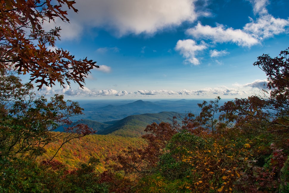
of the area and fall colors were in full effect! For the remainder of
our day we were greeted with sunny skies, fluffy white clouds, and
yellow leaves as we made our way up Tray Mountain to what would be our
first tent site of the trip. This summit gets a 5-star review from me
for views as, when you walk in to camp, there are eastward facing
campsites that would allow for an incredible view of the sunrise lit
valley. Alas, clouds were all we could see the following morning since
that was just our luck the entire trip!

To conclude the first half of the trip, Mark and I decided to stay at a
Bed and Breakfast in Hiawassee, GA to resupply our food and eat some
town food about four miles from the trail. The 10 miles that we hiked
that day absolutely flew by and I can wholeheartedly recommend Hiawassee Brew
as a place to eat some good food in an open atmosphere. They know how
to take care of hikers and quickly served us some of the best tacos,
burgers, and beers I’ve had in my life! What a first half of the
adventure!
We want to acknowledge and thank the past, present, and future generations of all Native Nations and Indigenous Peoples whose ancestral lands we travel, explore, and play on. Always practice Leave No Trace ethics on your adventures and follow local regulations. Please explore responsibly!
Do you love the outdoors?
Yep, us too. That's why we send you the best local adventures, stories, and expert advice, right to your inbox.


