
Kessler Peak in Utah's Big Cottonwood Canyon
Salt Lake City, Utah
Details
Distance
4.66 miles
Elevation Gain
2733 ft
Route Type
Out-and-Back
Description
Added by Chris Engelsman
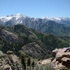
Kessler Peak in Big Cottonwood Canyon of Utah provides breathtaking views of the central Wasatch, Salt Lake Valley, and all the way to the Uintas.
Kessler Peak is a 10,403-foot peak located in Big Cottonwood Canyon. From the top, you can see all the way to the Uintas to the East, The tram at Snowbird to the south, and the Salt Lake Valley to the west. To the north is Mount Raymond and Gobblers Knob.
Kessler Peak is the terminus and highest point of the north ridge from Mount Superior.
There is nothing technically challenging about this trail, but it is steep. If you have trekking poles, I'd suggest you take them. They'll help keep your footing on the descent. The Kessler Peak trail stays cooler since it's mostly on the north side of the mountain.
Round trip the hike is approximately 4.7 miles and 2,700 of vertical. Depending on your level of fitness it could take anywhere from 2.5 to 4 hours for the hike. There are no signs for Kessler Peak trail, but it's easy to find.
Kessler Peak shares the Donut Falls Trailhead, which is very popular and has vault toilets. If the parking lot fills up, you'll have to park at the auxiliary parking lot on the Big Cottonwood road. Parking at Big Cottonwood road will add an extra mile or so to your hike, but there is little elevation gain.
From the Donut Falls Trailhead, follow the road past the gate, and continue up the path until you hit a fork at approximately .4 miles. Stay to the right and keep heading up.
After another 2/10th's of a mile (.6 total) you'll come to the Kessler Peak trail located on the right side of the road (west). There is no sign, but it's a steep rocky climb. From here the climb will be a steady ascent to the north-east ridge. From here you'll get some glimpses of Kessler Slabs, the northeast side of Kessler, and of Cardiff Fork, and Cardiff Pass in the distance.
Just after the 2-mile mark, you'll head across an avalanche path called God's Lawnmower, which is an excellent backcountry ski run in the winter.
A little less than a mile later you will come to the remains of an old miners cabin and their mine. The mine is unblocked, and you can go about 100 feet into it - maybe further if you are daring.
You're almost to the saddle, which has the remains of another miner's cabin, and a mine shaft that goes straight down. Don't fall in.
From the saddle, follow the path to the right. There are a series of false summits. Just stay on the trail, and you'll reach the summit.
At the top of Kessler Peak, enjoy the views of Hidden Peak and the Snowbird tram to the south, Twin Peaks to the West, Mount Raymond to the North, and Clayton Peak at Brighton Resort to the East.
Download the Outbound mobile app
Find adventures and camping on the go, share photos, use GPX tracks, and download maps for offline use.
Get the appFeatures
Reviews

The is my favorite "local secret" hike near me. I go there for solace and meditation. It's beautiful in the fall when the aspens turn golden. Don't tell anyone about it! : )
5.0
HOW TO FIND THE TRAILHEAD: I missed the trail at first and added some extra mileage. Start on the donut falls trail, once you cross a bridge over the creek you'll see a trail sign with an arrow pointing left. Ignore the left arrow and go straight through to get to a fire road (FR019). Go left on the fire road after less than a mile the unmarked kessler peak trail comes up on the right but is easy to miss. As of June 2018 it is marked with a small carin but the trail itself is narrow and looks like a washed out creek bed. If you come to a flat gravel clearing on the left you have gone too far. The hike starts with the very busy donut falls trail, but once you get on the Kessler trail you'll have the woods to yourself. The first half of the trail is narrow and pretty overgrown so I'd recommend long pants. The brush clears up a bit at higher elevations but the trail is very steep the whole way. This hike actually made me finally give in and buy trekking poles since on the way down I had to find a walking stick in the woods just to keep my balance on the loose dirt and rocks on the way down. There are a couple abandoned mines near the top and once you make it to the summit the views are incredible!
4.0

I love steep hikes, and I love them even more when they're not super crowded. Hiking in Big or Little Cottonwood can be crowded sometimes, but Kessler is not a super popular peak so I didn't see anyone when I did it. It was steep but beautiful. I went in early June, and there was still quite a lot snow so make sure to check conditions before going!
5.0
Leave No Trace
Always practice Leave No Trace ethics on your adventures and follow local regulations. Please explore responsibly!
Nearby

Backcountry Ski Cardiff Fork

Snowshoe to Cardiff Mine

Big Cottonwood Canyon Astrophotography

Donut Falls

Hike Cardiff Fork

Hike Days Fork
Community
Mobile Apps

© 2023 The Outbound Collective - Terms of Use - Privacy Policy