
Backpack the Grayson Highlands
Mouth of Wilson, Virginia
Details
Distance
9.1 miles
Elevation Gain
1549 ft
Route Type
Out-and-Back
Description
Added by Sam Dennis
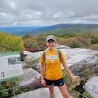
Mountains, Mountain Ponies, Mountain Meadows, and More Mountains. The Grayson Highlands offer a stunning out of the norm hike, often described as having similarities to the Scottish Highlands, for hikers used to the type of trails that commonly encompass the Blue Ridge.
Spanning roughly 4500 acres, located in a portion of Jefferson National Forest, looming under the highest peak in Virginia lies the Grayson Highlands. A part of Virginia’s State Parks system and a United States National Landmark, located in Mouth of Wilson, Virginia, the Highlands are home to wild mountain ponies, rolling mountain balds with rocky outcroppings, densely spruce-fir covered Mt. Rogers (the highest natural point in the Commonwealth of Virginia at 5729 ft.), and the Appalachian Trail. For this featured hike there is little to no tree coverage, except for at the base of Mt. Rogers upwards to its summit, but for the most part it is quite sparse allowing for some remarkable views of the surrounding mountains and the indigenous ponies grazing in between the mountain meadows. Not always native to the area, the ponies were introduced to the Highlands by the state park service in 1974 to help protect the area from wildfires with their appetites for grasses and underbrush. The Wilburn Ridge Pony Association now manages the pony population, which caps out around 150 ponies or so. Multiple herds of ponies can be seen throughout the Grayson Highlands State Park, a majority of which being located near Rhododendron Gap on the trail towards Mount Rogers, where this featured hike ventures.
Remember that the Highland ponies are wild even though more often than not act very friendly to everyday wonderers and will come right up to you in the hopes of receiving a tasty treat although park rules prohibit feeding said ponies.
The Grayson Highlands are about an hour and a half drive from Boone, NC through West Jefferson into Virginia. The address is: Grayson Highland Ln., Mouth of Wilson, VA. 24363.
From King Street head southeast down US-421 for 10.6 miles, then turn left onto US-221 N and continue another 12.4 miles until reaching US-221 BUS N. Take a left at the light onto US-221 BUS N towards West Jefferson. Continue on US-221 BUS N for 1.7 miles, eventually transitioning into NC-194 N/N Jefferson Ave. Drive another 5.3 miles down NC-194 N/N Jefferson Ave then turn right to stay on NC-194 N for 3.7 miles making another right at the Pie on the Mountain restaurant to stay on NC-194 N for an additional 4.8 miles. Next, you will make a left onto Helton Creek Rd from NC-194 N and drive 2.3 miles transitioning into State Rte 751/State Hwy 751, continue for 1.2 miles then turn right onto US-58 E (Highlands Pkwy). Drive for 3.4 miles on US-58 E and then turn left onto VA-362 N (Grayson Highlands Ln), continuing 1.8 miles until meeting the main entry to the Grayson Highlands State Park. Pay the entry fee of $5 to $7 dollars depending on the day of week, time of year, or out of state status. From the main entry, continue straight on Grayson Highlands Ln taking the third road on your right for the Massey Gap Overnight Parking. Park your car and start your adventure!
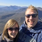
The trail to Mt. Rogers is accessible year-round unless the Grayson Highlands State Park is closed. The trailhead is accessed via Massey Gap Overnight Parking lot (see attached image). From the parking area, cross the field adjacent to you and continue through the wooden gate to start on the trail. Stay your course down Rhododendron Trail for ¾ of a mile eventually intersecting with the Virginia Highlands Connector Trail. Take the trail on the left for a ¼ mile. When you reach the junction for the Appalachian Trail, you can either head northwest on the AT towards Mt. Rogers or take a slight detour east to climb around on the rocky outcroppings nearest you, allowing for some epic 360-degree views of the highlands surrounding you before heading back towards Mt. Rogers. Continuing on the main trail you will come to a second gate. Pass through the gate leaving the Grayson Highlands State Park and enter into the Mount Rogers National Recreation Area. Continue straight on the AT for another ¼ mile until the trail forks, heading either straight on the Appalachian Trail or branching off to the left towards the Wilburn Ridge Trail; both trails are roughly 1 mile in distance. Wilburn Ridge is more of a challenge than the AT route… so take Wilburn Ridge. Scramble up the rocky outcropping of the Wilburn Ridge trail until reconnecting with the Appalachian Trail. Once back on the AT continue for 1 mile until you reach a multi-trail junction. You are now at Rhododendron Gap with a maximum elevation of roughly 5500 feet. At the junction, make sure to climb up the rock pinnacle nearest you for some breathtaking panoramic views, one of the main highlights of the adventure in my opinion. For those hiking in the fall, the pinnacle is a great spot to view the leaf change, reminding me of something out of a Robert Frost poem. After taking in the picturesque scenery, descend from the rock pinnacle to where the Appalachian Trail joins with the Crest and Pine Mountain Trails. Stay on the white blazed trail to continue on the AT. Stay your course for another 1 ½ miles through the Crest Zone, a Mountain Bald area or a mountain meadow if you will. Just past the Crest Zone is the Thomas Knob shelter, a two story wooden structure for those who do not feel like slugging around a tent for their overnight stay. Just past the shelter, you will enter the Lewis Fork Wilderness. A few minutes into the Lewis Fork Wilderness, you will branch off the AT for the Mount Rogers Spur Trail to the summit of Mt. Rogers. Continue for another ½ mile to the summit. The highest point in elevation on Mt. Rogers is marked by a USGS benchmark. After reaching Virginia’s highest point, turn back around for the journey back to Massey Gap.
A word of warning about Mt. Rogers is that the mountain is covered by a spruce-fir forest, so do not expect any incredibly awesome summit views of the surrounding landscape.
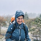
One thing to note about the area and its lack of tree coverage is that it results in a fair amount of wind throughout the Highlands, so make sure you dress appropriately. Wind resistant clothing and something to cover your face is the way to go, especially in the colder months. Just make sure to check the weather report before venturing out this way, especially if you are wanting to camp. It is always somewhat of a challenge to camp at the Grayson Highlands due to the seemingly constant windy weather but if you’re up to the challenge it can be quite the experience. The area encompassing the route to Mt. Rogers contains multiple primitive and not so primitive camping spots to fit whatever setting campers wish. Camps range from tree covered campsites, to sites in between mountain meadows where the local residents graze, or even a wooden shelter near the Lewis Fork Wilderness. I typically go to the halfway point between Wilburn Ridge and Mt. Rogers where you can usually find a spot that blocks the majority of the wind while offering decent views of the meadows to the west and the distant Virginia Mountains to the east. Usually there is plenty of dead shrubs and smaller trees around for fires, but it is never a bad idea to pack some backup kindling before venturing out to camp. There are hardly any water sources around and the ones that are in the Highlands are within natural protection areas so make sure to pack plenty of clean drinking water for cooking and the trek there and back. For an overnight hiking/camping excursion, I typically use 200+ fluid ounces. Remember, it never hurts to over pack… unless you have a hurt back (see what I did there with “pack” and “back”). One last thing to note is that there has been bear sightings in the area so make sure to hang-up any food before calling it a night.
No adventure to the outdoors is the same so cherish every opportunity to get out there and explore. The Highlands are an incredible natural area, unique in its own way so be respectful and pick up any trash that you might see on the trail.
Download the Outbound mobile app
Find adventures and camping on the go, share photos, use GPX tracks, and download maps for offline use.
Get the appFeatures
Reviews

So much room to explore. The wild ponies are such a delight to see. Most people come here only to see the ponies, and it might take some time to find them. They do like to travel in groups, so if you see one, you're on the right track.
5.0
This trail is rather easy to traverse. It is a dirt trail, but it’s not difficult to hike. The trail itself is well maintained. There are wide open spaces along the trail that are rather majestic when paired with the layers upon layers of Blue Ridge Mountains. The trail itself has a bit of incline, but nothing overly steep. Along the trail you can see a variety of shrubbery and wildflowers as well as wild horses and wild cows. This trail is perfect to backpack along or go a shorter distance for a day hike. It would be suitable for older children (or super experienced little hikers) as well as dogs that are up for a bit of a challenge.
5.0
This trail is a must do for anyone on the east coast! The Mountain view’s are stunning, and there is an endless amount of wildlife! :-)
4.0
Leave No Trace
Always practice Leave No Trace ethics on your adventures and follow local regulations. Please explore responsibly!
Nearby

Mount Rogers via Appalachian Trail

Photograph Wild Horses at Grayson Highlands State Park

Hike and Fish Cabin Creek Trail

Rhododendron Trail to Rock Croppings

Wilburn Ridge and Massie Gap Loop

Twin Pinnacles via Big Pinnacles Trail
Community
Mobile Apps

© 2023 The Outbound Collective - Terms of Use - Privacy Policy