
Mount Rogers via Appalachian Trail
Mouth of Wilson, Virginia
Details
Distance
9.1 miles
Elevation Gain
1549 ft
Route Type
Out-and-Back
Description
Added by Christin Healey
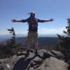
This trail is also the highest point in Virginia, and because of wildfires, it is all big skies and pine trees, making it feel like somewhere out west rather than Southern Virginia.
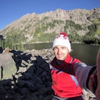
First of all, who doesn't love wild ponies! There are tons of ponies here, and although they are wild, they are not afraid of people and you can get pretty close (just don't feed them!).
Once you enter Grayson Highlands State Park, you will see a parking lot for Massie Gap a few miles in, park here. There is an obvious trail, the Rhododendron Trail, that you will follow for about .5 mile until you reach the AT. Turn left, follow the AT to Wilburn Ridge, go past the Thomas Knob Shelter until you reach the short spur that leads to the Mount Rogers summit. There are no real views at the summit, but plenty along the hike to get there. Round trip the hike is 10 miles.
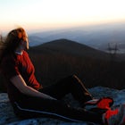
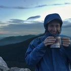
In the springtime there are tons of rhododendron, blueberries in late summer, and fiery colors in the fall. To top it all off, there are plenty of great campsites and shelters as well as nearby water sources. Dogs are also welcome and from personal experience, love this hike :) This can also be done as a day hike if you don't want to camp.
Download the Outbound mobile app
Find adventures and camping on the go, share photos, use GPX tracks, and download maps for offline use.
Get the appFeatures
Reviews

A must visit, absolutely stunning views
5.0

The sweeping views, wild ponies, and ample space to hike and camp make this area one of my favorites in the entire state. I've hiked or camped at Mount Rogers a few times, each very different from the last! Highly recommend stopping in Abingdon afterwards for a bite!
5.0

Horses are so friendly, it is wide open. Easy to follow directions!!! 10/10!
5.0

Such a beautiful hike with so many different terrains and landscapes! I felt like I was somewhere far far away from Virginia! There are tons of great backcountry campsites as the trail is located along the AT. It's super dog friendly and the ponies come right up to you!
5.0

We hiked in from Massie Gap to Mount Rogers in late June and we quickly decided this was our favorite hike we've ever done. This hike offers the most beautiful views I've ever seen in the United States, and hiking among the ponies is one you won't soon forget! Plenty of beautiful camping spots. We hope to come back one day.
5.0
I seriously loved this hike and it easily tops all the other hikes I've done this far in Virginia!
5.0
Absolutely a must-do hike. Went for a nice weekend trip in Virginia after day hiking McAfee Knob. We went on a Sunday and Monday and it made a world of difference with the crowds.
5.0
As other reviews have hinted at...hiking here feels more like being in the Scottish Highlands than in Virginia. The wild ponies are definitely a plus, just please resist the urge to feed them. There are many places to pitch a tent if wanting to turn this hike into a backpacking trip. Though the summit of Mt. Rogers is forested, this is one of only a few mountains in Virginia with high enough elevations to have a spruce-fir forest, making the trail to the summit quite enchanting.
5.0
Came here as a part of a group for my first true backpacking trip and now I'm hooked! We stayed near shelters both nights so the easy access to water sources and privys made things a little easier for a beginner. Covered about 15 miles over the weekend and couldn't believe all the different scenery we saw. Loved the challenge of the rock scramble sections! Getting to see the ponies made the weekend absolutely perfect. Can't recommend this enough.
5.0
Just go. We got to see the herds of wild ponies three times on our day hike up and back. The scenery is some you would never imagine in Virginia. The horses manage to keep a lot of the hike well grazed leaving for countless incredible views all along the hike. The summit itself is well forested, so it doesn't have any view, but if you there you might as well make it to the highest point in VA. This hike is a must!
5.0
Leave No Trace
Always practice Leave No Trace ethics on your adventures and follow local regulations. Please explore responsibly!
Nearby

Backpack the Grayson Highlands

Photograph Wild Horses at Grayson Highlands State Park

Rhododendron Trail to Rock Croppings

Hike and Fish Cabin Creek Trail

Wilburn Ridge and Massie Gap Loop

Twin Pinnacles via Big Pinnacles Trail
Community
Mobile Apps

© 2023 The Outbound Collective - Terms of Use - Privacy Policy