The Best Backpacking in Oregon
Looking for the best backpacking in Oregon? We've got you covered with the top trails, trips, hiking, backpacking, camping and more around Oregon. The detailed guides, photos, and reviews are all submitted by the Outbound community.
Top backpacking spots in and near Oregon
-
Klamath County, Oregon
The Rim at Crater Lake NP
4.330.99 mi / 4124 ft gainWhy Go? Avoid the crowds in summer and have the entire 33 mile long rim and 21 square miles of beautiful Crater Lake to yourself. Sunrises and sunsets that will take your breath away; stars and a milky way you can get lost in for days. Expect solitude and beautiful scenery, nothing less. The 360 ...Read more -
Deschutes County, Oregon
Broken Top Trail to No Name Lake
4.74.84 mi / 1198 ft gainThe hike takes you along a glacial lake and to unbeatable mountain views at the end. It’s a hidden gem! The trail isn’t marked and the best way to get there is know someone that’s been before. The lake is unbelievably beautiful with deep blue glacial water and the view of the mountains at the end...Read more -
Detroit, Oregon
Russell Lake via Whitewater Creek Trailhead
4.811.4 mi / 1926 ft gainThis hike begins 7.5 miles down Whitewater Road at the Whitewater Trailhead, about 10 miles east of Detroit Lake. The road is bumpy, but can be navigated at slow speeds, even without four-wheel drive. Make sure to fill out a wilderness pass once you arrive at the trailhead. The trail is very wel...Read more -
Linn County, Oregon
Coffin Mountain Fire Lookout
5.02.67 mi / 873 ft gainCoffin Mountain Fire Lookout is a beautiful day hike that takes you to its summit at 5771 feet elevation, covering roughly 1070 feet elevation gain. To get to the Coffin Mt. trailhead from Detroit OR, travel east on Highway 22 for approximately 19.5 miles to Forest Road 11 (Straight Creek Road)....Read more -
Detroit, Oregon
Battle Ax Mountain
5.05.09 mi / 1594 ft gainWith no officially marked trailhead, this hike begins slightly west of Elk Lake in Marion County. Take Highway 22 to Detroit, OR. East of the bridge over Breitenbush River, turn onto (FR) Forest Road 46, with signs pointing to Breitenbush River. After 4.5 miles turn left at a sign for Elk Lake, a...Read more -
Detroit, Oregon
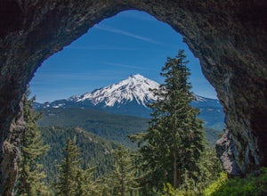
Boca Cave & Triangulation Peak
4.04.75 mi / 1053 ft gainTriangulation Peak, Spire Rock and Boca Cave TH #3372 The trail starts on level ground where you travel east along the top of the ridge. There are multiple trees that have fallen across the trail making the hike quite adventurous. Some trees you'll go over and some you will need to go under. Dep...Read more -
Bend, Oregon
Tam McArthur Rim, Green Lakes, Park Meadow Tie Loop
3.322.58 mi / 3675 ft gainThis loop trip around Broken Top is one of the premier backpacking loops in Oregon. The trail winds past numerous alpine lakes, including the popular Green Lakes area, and offers near-constant views of Broken Top, the Three Sisters, and Mount Bachelor. To top it all off, the clear skies typical o...Read more -
Government Camp, Oregon
Tom Dick and Harry Mountain
5.08.28 mi / 1726 ft gainLooking to score those iconic photos of Mt. Hood? Climb the well-graded trail to Tom Dick and Harry Mountain, one of the most accessible summit hikes to Portlanders, and see where they were all taken. Starting from the busy Mirror Lake Trailhead, climb roughly 900 feet and 1.5 miles to Mirror La...Read more -
Camp Sherman, Oregon
Black Butte
4.53.94 mi / 1493 ft gainJust outside of Sisters Oregon is the stunning and popular day hike to the summit Black Butte (Elevation 6,436 feet). At the top, spectacular views of the surrounding Cascades await the intrepid hiker. To get to the trailhead, turn off of Highway 22 onto National Forest Road (NFR) 11, also known...Read more -
Lane County, Oregon
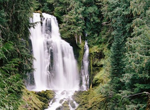
Hike to Linton Falls
4.5Hiking to Linton Falls accounts for the two larger waterfalls on the cascading Linton Creek. The hike begins at the trailhead to Linton Lake, off the Mackenzie Pass Highway (242) about 8 miles east from the junction with Highway 126.The first 1.5 miles of the trail to Linton Lake is relatively ea...Read more -
Mount Hood, Oregon
McNeil Point via Top Spur Trailhead
4.97.17 mi / 2428 ft gainThe hike to McNeil Point begins at Top Spur Trailhead, in the Mt. Hood National Wilderness. Follow signs for McNeil Point along the Pacific Crest and Timberline Trails heading north. Though there are numerous camping opportunities along the way (most of the route follows the PCT), an old stone s...Read more -
Bend, Oregon
Green Lakes Trail
5.09.19 mi / 1240 ft gainThis 8.5 mile roundtrip hike to Green Lakes basecamp gains elevation gradually as it meanders along beautiful Fall Creek with numerous small cascades. Depending on the season (expect significant snow on the trail through early-to-mid June) the stark contrast of the snow with creek is beautiful, t...Read more -
Enterprise, Oregon
Mirror Lake via Two Pan Trailhead
4.713.49 mi / 2280 ft gainMirror Lake, one of the most photogenic and peaceful lakes in the area, is accessible via the Two-Pan Trailhead, off of Upper Lostine Road. The hike follows the river that flows down from the Lakes Basin, so water is plentiful throughout. You will slowly move up the valley, crossing the river a ...Read more -
Clackamas County, Oregon
Climb Squaw Mountain
4.7On a clear day, this short, secluded hike offers breath-taking views of Mt. St. Helens, Rainier, Adams, Hood, and Jefferson, as well as of downtown Portland, Coast Range, and the Roaring River Wilderness.Begin the hike from the Twin Springs Trailhead and immediately take your first left at the T....Read more -
Cascade Locks, Oregon
Climb to the Top of Mount Defiance, OR
3.712 mi / 4870 ft gainThis hike starts at the Starvation Creek Rest Area. After parking, head west back along the shoulder of the freeway, where you’ll see a wooden sign stating “Mt. Defiance Trail.” Continue heading west along the abandoned Columbia River Highway. Keep going west as you pass the junction with the Sta...Read more -
Cascade Locks, Oregon
Tomlike Mountain
4.57.65 mi / 1198 ft gainBeginning at the Wahtum Lake trailhead, follow the Wahtum Lake Express trail down to the shore and head east (right) around the lake. At the junction with the Pacific Crest Trail, follow the Herman Creek Trail to the east (right, again). You'll begin your ascent out of the Wahtum Lake bowl and to...Read more
Quick links
- The best hiking trails in Oregon
- The best backpacking in Oregon
- The best camping in Oregon
- Top adventures in Oregon
More Oregon Destinations
- Portland
- Bend
- Cascade Locks
- Sisters
- Deschutes County
- Lane County
- Crescent
- Mount Hood
- Brookings
- Corvallis
- Government Camp
- Deschutes
- Tillamook
- Joseph
- Princeton
- Crater Lake
- Eugene
- Coos Bay
- Douglas County
- Klamath County
- Klamath Falls
- Terrebonne
- Ashland
- Clackamas County
- Corbett
- Detroit
- Florence
- Gold Beach
- La Pine
- Port Orford
- Prospect


