
Cibecue Falls
Gila County, Arizona
Details
Distance
2.94 miles
Elevation Gain
600 ft
Route Type
Out-and-Back
Description
Added by Matt Yanchek
A canyoneering adventure to see another one of Arizona's incredible waterfalls.
It is a bumpy ride down an old dirt road to get to the trailhead. Use extreme caution on this road as there are very narrow sections with sheer cliffs. The road follows along the Salt River giving you a nice viewpoint of the Salt River Canyon. On your way in you will pass the campgrounds (First and Second Campgrounds), just make note of this if you plan on spending the night. A few feet before the trailhead is the Cibeque Creek which you must drive over, so be prepared. For you off-roaders, it is always fun driving through running bodies of water! Permits are now required, which you can find more info on here. You can also call White Mountain Apache Tribe Game & Fish for updates and trail conditions: (928) 338-4385.
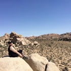
Immediately after crossing the creek there is a clearing for parking on the right. There is also a sign with a list of rules, please be considerate of them. The trailhead starts you off at about 2900 ft of elevation. This is more of a canyoneering style hike as the trail criss crosses a lot from bank to bank of the creek. Your feet will get wet. Because most of the trail is in the creek they will be a lot of rock jumping. For those dogs that love the water this hike is a heaven for them. Some areas in the creek can get pretty deep and as the sign says swimming is not allowed some areas are deep enough to do so. It's a fun two mile hike up the creek with spectacular views of the canyon and all the little water features the creek has to offer. Since you are a canyon there is plenty of shade and the water tends to keep you nice and cool. The closer you get to the falls the more narrow the canyon becomes and you start to notice the beauty of it all. Just before the falls is a natural cave/alcove. The water fall itself is about 30 feet high and has significant water flow.
It is a peaceful little place here in the desert. You exit the way you came in. If camping afterwards the sites are very primitive. They provide shade structures but not much more. Some sites have fire rings others don't. I did not see any picnic tables and the restrooms are pretty basic. It is a nice peaceful spot right by the salt river. Always be mindful of the wildlife, during our stay we woke up to a black bear fishing in the river right across from camp.
Download the Outbound mobile app
Find adventures and camping on the go, share photos, use GPX tracks, and download maps for offline use.
Get the appFeatures
Reviews

Just FYI, I got super excited to do this hike and started looking into getting a permit and discovered that this area is currently closed, maybe permanently. Make sure you check before you go!
5.0
The views are beautiful!! However, just because dogs are allowed on the trail, I would not say it is a dog friendly trail. Our 80 pound dog who has hiked with us across the country, needed to be picked up and lowered back down to get over some of the boulders. Her paws became cut and deeply gouged by the riverbed rocks. We felt horrible after bringing her there because she couldn't walk. You may lose cell service just prior to the turn off, leaving GPS useless. The brown wooden sign with yellow lettering is not easily seen from the main roadway, which left us driving past it. Just know, that when you get to the bottom of the Salt River Canyon, you need to turn into what appears to be a parking lot, but is actually the correct road. It is a poorly maintained dirt road down to the trail. A vehicle with some ground clearance may be your best bet. The trail itself is not well marked. It crosses in and out of the river. With all of that said, it is still an absolutely beautiful, remote, hike, and the waterfall at the end is breathtaking!
4.0
This hike was breathtaking, and not too difficult. My sister and I were able to make it to the falls pretty easily. There is no cell service, so just be aware of that when escaping to the serene falls. I would highly recommend this hike and view to anyone!
5.0

Way easier of a hike than I thought it would be. The only “hard” part is crossing the creek and getting over some of the bigger boulders sometimes. It’s more fun than strenuous though. Very worth the view! But the permit online and save yourself the time and money.
5.0

I hiked the falls with two dogs and I’ve never seen them have so much fun! Crossing the river and climbing over rocks was quite the adventure. The falls at the end are so worth it. Be sure to be ready to get wet crossing the river.
5.0

My husband and I took our 6 and 10 year olds here yesterday. We had a blast. We'll definitely be going back again! The canyoneering was a bit intimidating, as our kids a still relatively young and inexperienced, but they both rocked it! It was much easier than we'd originally anticipated. The day was so perfect. It was pretty warm out, but the back and forth through the creek perfectly complimented the day! I absolutely recommend this trail for anyone who loves adventures and gorgeous scenery!
5.0
Today we hiked Cibicue Falls for the second time ever and man was it a blast. The weather was in the mid 60's but with the heat of the sun it was absolutely stunning. The water was pretty clear so it made it easy to see where you were walking when crossing the water. The water was cold but refreshing. Hiking with trekking polls made it extremely easy most of the time, you do climb up boulders so that's when I would put them to the side. Last thing I would like to mention is MAKE SURE YOU BUY THE CORRECT PASS! If you are hiking this trail you must pay the $15 PER PERSON special use black/salt river daily pass. If you don't have it you will need to drive back on the highway till you have cell service to pay for one online if you don't have cash with you. If you have cash you can pay at the beginning of the dirt road that leads you to the trailhead.
4.0

Drove 2.5 hrs from Phoenix to check this place out so my mother in law and I get there and only have $15 cash unfortunately they are not with the current century and only accept cash or check, there's no one that works there and they charge $15 per person. There was no indication what the charge for permits would be on any site so the drive was a waste of time. Be sure to bring plenty of cash to support the communities drinking habits.
1.0
It was a great hike! The path is fairly easy to follow and even if you can't the creek is shallow enough to walk through. We went the day after a monsoon storm. I don't recommend it as the water looked like chocolate milk and there was debris from a possible flash flood the night before. But absolutely loved this hike and would do it again.
4.0

this hike is amazing - it's more like a stroll down the creek with beautiful canyon views along the way. I would suggest wearing some sort of hiking water shoe because you will zig zag across the creek & your feet will get very wet (some points on the hike the water was up to or knees) The waterfall at the end if beautiful & very peaceful. Highly recommend this hike to all levels.
5.0
Leave No Trace
Always practice Leave No Trace ethics on your adventures and follow local regulations. Please explore responsibly!
Nearby

Apache Falls

Camping on Roosevelt Lake Overlook

Visit Tonto National Monument

Hike on Rim Lakes Vista Trail #622

Mogollon Rim Interpretive Trail

Camp At Burnt Corral Campground On Apache Lake
Community
Mobile Apps

© 2023 The Outbound Collective - Terms of Use - Privacy Policy